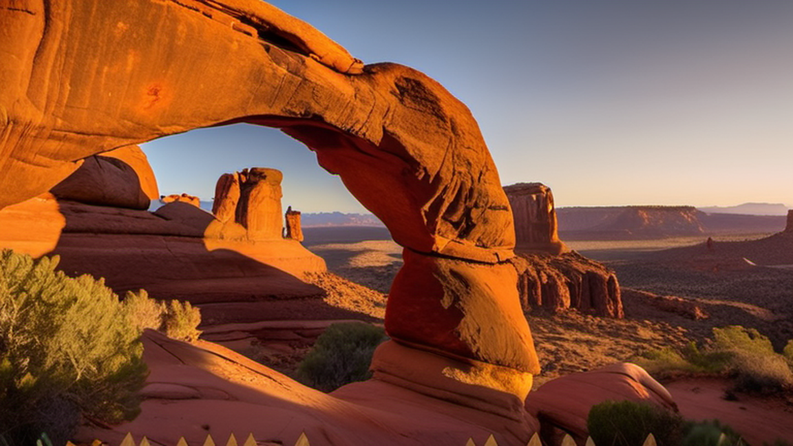
Arches National Park is a national park of the United States in eastern Utah. The park is adjacent to the Colorado River, 4 mi (6 km) north of Moab, Utah. The park contains more than 2,000 natural sandstone arches, including the well-known Delicate Arch, which constitute the highest density of natural arches in the world. It also contains a variety of other unique geological resources and formations. The national park lies above an underground evaporite layer or salt bed, which is the main cause of the formation of the arches, spires, balanced rocks, sandstone fins, and eroded monoliths in the area.
The park consists of 310.31 km2 (76,680 acres; 119.81 sq mi; 31,031 ha) of high desert located on the Colorado Plateau. The highest elevation in the park is 5,653 ft (1,723 m) at Elephant Butte, and the lowest elevation is 4,085 ft (1,245 m) at the visitor center. The park receives an average of less than 10 in (250 mm) of rain annually.
Administered by the National Park Service, the area was originally designated a national monument on April 12, 1929 before being redesignated a national park on November 12, 1971. The park received more than 1.8 million visitors in 2021. This has declined in recent years with visitor numbers in 2024 being just under 1.5 million.
Arches National Park is a national park that is in Utah's Canyon Country near the town of Moab. It is home to the world's greatest concentration of natural arches, including Delicate Arch, one of the state's most famous icons.
Arches National Park preserves over 2,000 natural sandstone arches. This area contains the largest concentration of arches found anywhere in the world, including the world-famous Delicate Arch as seen on the Utah state license plate, in addition to a variety of unique geological resources and formations. In some areas, faulting has exposed millions of years of geologic history. The extraordinary features of the park, including balanced rocks, fins and pinnacles, are highlighted by a striking environment of contrasting colors, landforms and textures.
Throughout the park, rock layers reveal millions of years of deposition, erosion and other geologic events. These layers continue to shape life in Arches today, as their erosion influences elemental features like soil chemistry and where water flows when it rains. Arches is in a "high desert," with elevations ranging from 4,085 ft (1,245 m) to 5,653 ft (1,723 m) above sea level.
In 1923 Alexander Ringhoffer, a prospector, wrote the Rio Grande Western Railroad in an effort to publicize the area and gain support for creating a national park. Ringhoffer led railroad executives interested in attracting more rail passengers into the formations; they were impressed, and the campaign began. The government sent research teams to investigate and gather evidence. In 1929, President Herbert Hoover signed the legislation creating Arches National Monument, to protect the arches, spires, balanced rocks, and other sandstone formations. In 1971 Congress changed the status of Arches to a National Park, recognizing over 10,000 years of cultural history that flourished in this now famous landscape of sandstone arches and canyons.

For photographers and quiet‑minded walkers, the park’s orientation makes sunrise and sunset worth planning around. The western arches, such as Landscape Arch, soak up the low winter sun, casting long shadows that accentuate the fins. In late summer, the high desert heat holds the sun low longer, offering a softer, amber glow that brings out the pinkish streaks in the sandstone. Early morning also means fewer cyclists on the main road and cooler trail temperatures, crucial for tackling the more exposed paths like the 4.5‑mile hike to Fiery Furnace, where midday heat can turn a pleasant trek into an exhausting slog.
Most visitors stick to the well‑marked loops near the visitor centre, but the park’s back‑country roads hide a network of primitive campsites and lesser‑known viewpoints. The Devil’s Garden trail, for instance, extends past the famous Landscape Arch into a quieter section where Tower Arch and the precarious Balanced Rock stand with far fewer cameras. Because the area lacks regular shuttle service, hiring a local Moab guide for a day‑trip offers insight into the ancient Puebloan pathways that once linked these formations, and provides a safer route through the occasional flash‑flood drainage channels.
To many, the most outstanding natural features of Arches are the park's geologic formations. Over 2,000 cataloged arches range in size from a three-foot opening (the minimum considered to be an arch), to Landscape Arch which measures 306 ft (93 m) from base to base. Towering spires, fins and balanced rocks complement the arches, creating a remarkable assortment of landforms in a relatively small area.
Two unusual natural features common in Arches intrigue both scientists and visitors: cryptobiotic soil and potholes. Cryptobiotic soil is a living groundcover that forms the foundation of high desert plant life.
Potholes are naturally occurring basins or pools in sandstone that collect rainwater and wind-blown sediment. These potholes harbor organisms that are able to survive long periods of dehydration, and also serve as a breeding ground for many desert amphibians and insects. Both of these communities are very vulnerable to human impacts.
The plants and animals in Arches have many adaptations that enable them to survive these conditions. Some species are found only in this area. The diversity of organisms reflects the variety of available habitat, which includes lush riparian areas, ephemeral pools, dry arroyos, mixed grasslands and large expanses of bare rock.
Generally, the trees of Arches grow small and far away from each other. However, mixed stands of Pinyon pine and Utah Juniper, two trees that thrive in dry, rocky environments, can be found throughout the park. In Arches, there is more tree diversity in riparian environments where there is plenty of water. In such locales, trees such as netleaf hackberry, box elder, and Fremont's cottonwood can be found. Nine species of cacti can be found in the park, as well as many types of desert wildflowers and shrubs.
Nearly 50 species of mammals can be found in Arches National Park. Among the more commonly sighted mammals are mule deer, desert bighorn sheep, desert cottontail rabbit, and kangaroo rat. Other large mammals, such as the mountain lion, are present but rarely spotted.
Although Arches National Park is not a birding hot spot, 273 species of birds have been spotted in the park. Species such as Spotted Towhee and Canyon Wren can be found near water in spring and summer. In drier grasslands and pinyon-juniper woodlands of the park, Say's Phoebe, Black-throated Sparrow, Western Meadowlark, Juniper Titmouse, Pinyon and Scrub Jays, and Lucy's and Black-throated Gray Warblers are present. Common Raven will likely be seen by nearly all visitors, and can be spotted throughout the park. Cooper's Hawk and Turkey Vulture are among the birds of prey that glide above Arches' desert landscape.
Arches is home to many reptiles as well. These include 10 species of lizards and 9 types of snakes. Venomous rattlesnakes are present, but are reluctant to attack, so use common sense and caution when observing them.
Southeast Utah is part of the Colorado Plateau, a "high desert" region that experiences wide temperature fluctuations, sometimes over 40 °F (4 °C) in a single day. The temperate (and most popular) seasons are spring (April through May) and fall (mid-September through October), when daytime highs average 60 to 80 °F (16 to 27 °C) and lows average 30 to 50 °F (−1 to 10 °C).
Summer temperatures often exceed 100 °F (38 °C), making strenuous exercise difficult. Late summer monsoon season brings violent storm cells which often cause flash floods.
Winters are cold, with highs averaging 30 to 50 °F (−1 to 10 °C), and lows averaging 0 to 20 °F (−18 to −7 °C). Though large snowfalls are uncommon (except in nearby mountains), even small amounts of snow or ice can make local trails and roads impassable. Winters are also the low season, when the trails are quiet and parking is plentiful.
Local weather conditions and forecasts are available by phone at ☏ +1 801 524-5133.
Dust storms can develop in the region, and weather is unpredictable; dust devils are not rare.
Park website
Moab's Canyonland Field Airport has daily service to Denver on Great Lakes Airlines. The next closest major airports are:
Salt Lake City International Airport in Salt Lake City, about a 4-hour drive away by way of Interstate 15 and US Highway 6/191.
Walker Field in Grand Junction, approximately 2 hours from the park via Interstate 70.
Denver International Airport in Denver, about 5 hours 45 minutes via Interstate 70.
The 1 entrance to Arches National Park is located 5 miles (8 km) north of Moab along US Highway 191.
Most visitors see Arches National Park on their own, driving automobiles or riding bikes. However, there are a few privately operated tour companies authorized by the National Park Service to provide visitors with guided trips into the park:
Canyonlands Tours/North American River Expeditions, 543 N. Main, Moab, ☏ +1-800-342-5938.
Desert Highlights, 50 East Center St., toll-free: +1-800-747-1342.
NAVTEC Expeditions, 321 N. Main St., Moab, toll-free: +1-800-833-1278.
Moab Adventure Center, 225 S Main Street, Moab, toll-free: +1-888-622-4097.
Entrance fees allow park entrance for seven days. As of 2020 the fees are:
$15 per person
$25 Motorcycle Fee
$30 Private Vehicle Fee
$55 Southeast Utah Parks Pass
The America the Beautiful Pass, also called the Interagency Pass, provides entry to Arches National Park and all national parks, as well as some national monuments, national wildlife refuges, and national forests. A single pass applies for an entire group traveling together in a private vehicle, or up to four people on foot or bike. There are several pass types:
The Annual Pass (valid for twelve months from date of issue) can be purchased by anyone. $80 for U.S. citizens and residents, $250 for non-U.S. residents, $20 for U.S. citizens or permanent residents age 62 or over, and free for current military personnel (must show a Common Access Card (CAC) or Military ID).
The Lifetime Pass (valid for the life of the holder) is available for $80 to U.S. citizens or permanent residents age 62 or over, and free for veterans and Gold Star families (families of servicemembers who were killed in action). Applicants must provide documentation showing they are eligible. This pass also provides a 50% discount on some park amenities.
The Access Pass (valid for the life of the holder) is available for free to U.S. citizens or permanent residents with permanent disabilities. Applicants must provide documentation of citizenship and permanent disability. This pass also provides a 50% discount on some park amenities.
The Volunteer Pass is available for free to individuals who have volunteered 250 or more hours with federal agencies that participate in the Interagency Pass Program.
The free Annual 4th Grade Pass (valid for September to August of the 4th grade school year) allows entry to the bearer and any accompanying passengers in a private non-commercial vehicle. Registration at the Every Kid Outdoors website is required.
In 2026, the National Park Service offers free admission to all national parks on 10 days:
President's Day (February 16)
Memorial Day (May 25)
Flag Day (June 14)
Independence Day Weekend (July 3-5)
The National Park Service Birthday (August 25)
Constitution Day (September 17)
Theodore Roosevelt's birthday (October 27)
Veterans Day (November 11)
If the entrance booth is not manned, there is an electronic kiosk to pay the entrance fee and receive a receipt to place on your vehicle's dashboard.
A car is the most common way of exploring the park; most visitors will drive to sites and then take short walks to view the amazing geologic formations of the park. There are several four-wheel drive roads in the park's backcountry that may appeal to those with appropriate vehicles.
There are numerous trails throughout the park. Hiking at or around sunrise (5-6AM) can provide a less crowded experience and easier parking.
Although the summer heat can make a bike a masochistic way of viewing the park, in cooler months it can be a popular option. Though there are no bike lanes and traffic can be heavy at times, biking the scenic drive is a great way to see the park. The Salt Valley and Willow Springs roads are less traveled but are more suited to mountain bikes due to washboards, deep sand and other obstacles. Bicycles are only permitted on roads: there is no single track or trail riding in the park. When biking on the main road, please use caution and ride single file on the edge of the lane.
1 Park Avenue. A relatively easy one mile (one-way) trail located near the park entrance. The trail leads through a steep-walled sandstone canyon with a smooth bottom. Many hikers will get dropped off at one end of the trail and picked up at the other to eliminate the need for a round-trip.
2 Double Arch. A 0.8-mile roundtrip leads to Double Arch, a massive joining of two arches that will be recognizable from the beginning of the movie Indiana Jones and the Last Crusade. The trail is very easy and located within walking distance of the Windows.
3 Windows. The North & South Windows, as well as Turret Arch, are located along an easy 1-mile roundtrip trail.
4 Wolfe Ranch. Near the beginning of the Delicate Arch trail, this ranch is a restored homestead of John Wesley Wolfe, who settled in the area in the late 1800s.
5 Delicate Arch. The most famous arch in the park, Delicate Arch can be seen from a roadside turnout, from a 0.8-mile trail, or you can take the 3-mile (roundtrip) trail starting from Wolfe's Ranch, gaining 480 ft (150 m) of elevation, and stand underneath this natural wonder. The trail to the arch is strenuous; be sure to carry adequate water with you. During peak season you are likely to be sharing the trail with many people; visiting at sunrise provides the best chance of solitude, while sunset offers the best photography.
6 Petrified Dunes. An overlook of the petrified dunes lies just off of the park road between the Courthouse Towers and the Windows Area. These colorful formations are ancient sand dunes, hardened into stone as additional layers built up on top of them and were later eroded away.
7 Fiery Furnace. The Fiery Furnace area is accessible only on ranger-led tours, which can be reserved online or at the visitor center. The tour leads through a maze of sandstone fins, showcasing one of the most interesting geologic areas in the park. A fee is charged for this tour and tours often sell out quickly, so trips should be booked as early as possible. Reservations can be made up to a week in advance at the visitor's center, or for the full season at the park's website.
8 Devil's Garden Trail. Devil's Garden is a series of sandstone fissures that are home to Landscape Arch (the park's largest), Double O Arch, and numerous others. A series of trails lead to the arches, with Landscape Arch only a 1.6-mile roundtrip from the trailhead, while Double O Arch is a more strenuous 4.2 mile roundtrip. Wall Arch, once one of the most photographed arches in the park, is no more; it collapsed in August 2008.
9 Klondike Bluffs. Visited by only a very small fraction of the park's tourists, Klondike Bluffs is in the northwest corner of the park and is accessible only by a dirt road or on foot. Tower Arch is located down a short trail, as is the formation known as the Marching Men.
The park is a paradise for photography with reddish brown rocks, distant snow-covered mountains, and fantastic rock formations. As with most places, light can be harsh during the day, so it is best to have the camera ready during the early morning hours and late evening hours. Delicate Arch and the Windows are best photographed at sunset, while the light on Landscape Arch and Double Arch is best near sunrise. Hike to Delicate Arch. The entire arch glows blood red at sunset with the mountains framed within Delicate Arch if you are lucky. The mountains will glow if you wait long enough. In addition, the Windows area is excellent for sunrise photos. Just get to the side where you can see Turret Arch framed by North Window. There is a ledge where you can take your photo although it requires some scrambling over fallen rocks. Those looking for a photograph of Double Arch should be aware that light at sunrise is minimal, although things improve as the sun rises further. Double O Arch is best in the late afternoon if hike through the arch and photograph from the photographers ledge.
The park offers numerous short hiking trails (see above) ranging in difficulty from very easy to moderate. Limited water supplies and a lack of true backcountry trails limit the appeal of backpacking in the park, although backcountry use is allowed. Inquire at the visitor center for details. Rock climbing is not allowed on most features named on USGS maps, but is allowed on other formations.
Wildlife Viewing is also popular. Almost 50 species of mammal are known to live in Arches. Some, like desert cottontails, kangaroo rats and mule deer, are common and may be seen by a majority of visitors. However, many desert animals are inactive during daylight hours or are wary of humans, so sightings can be truly special events. Tracks and scat are the most common signs of an animal's presence. Arches National Park Wildlife has more information on wildlife in the area.
1 Canyonlands National History Association Bookstore (Located in the Visitor Center, just past the Entrance Station on the right.), ☏ +1 435-259-6003, fax: +1 435-259-8263. Open every day except December 25th. Summer hours: 7:30AM to 6PM; Fall: 8AM to 4:30PM; Winter: 9AM to 4PM. The bookstore is a cooperating association sales outlet in the visitor center that offers books, maps, postcards, posters, and a variety of other educational and interpretive items. For a larger selection, the town of Moab has everything necessary to satisfy your shopping needs. (updated Apr 2015)
There is no food available within the park. There is a water fountain at the parking area near the Devil's Garden Trailhead. The nearby town of Moab offers a vast number of restaurants, convenience stores, and grocery stores.
There is no lodging within the park, although the nearby town of Moab has an enormous number of hotels to choose from.
There is only one campground within the park, and reservations are highly recommended. Outside of the park the Bureau of Land Management (BLM) operates several campsites, and there are a number of commercial campgrounds in and around Moab.
1 Devils Garden Campground (at the end of the park road, 18 miles from the park entrance). 51 sites, 2 group sites. Standard campsites can be reserved up to 6 months in advance for stays March 1-October 31. All sites are usually reserved months in advance. Between November 1 and February 28, sites are first-come, first-served. Facilities include drinking water, picnic tables, grills, and both pit-style and flush toilets. $25 Standard Individual Site (2020 rates). (updated Jun 2020)
Arches is a relatively small park, with very few areas far enough from roads to qualify as backcountry. Outside the developed areas there are no designated trails, campsites, or reliable water sources.
In order to backpack in Arches, you must obtain a backcountry permit at the visitor center. The maximum group size is ten, but smaller groups are strongly recommended to reduce impacts. Permits may not be reserved in advance. Backpackers should know how to navigate with a topographic map, recognize safety hazards and practice low-impact camping specific to the high desert. Primary safety considerations include steep terrain, loose rock, lightning, flash floods, and dehydration.
Pets may not accompany groups in the backcountry.
Stay on the path: Throughout the park and the Southwestern national parks, you will see warnings about cryptobiological soil. Footprints erode the soil and destroy years of growth.
Leave your dog at home: As the climate indicates, there is extreme heat in the summers. Perhaps more importantly, the environment is not supportive of domesticated pets. There are reasons that there are still 1000-year-old corn cobs in archeological sites: items do not deteriorate like they might in your backyard. Cactus and Fido do not make for good bedfellows. Dogs are not allowed on any park trails.
Leave only your footprints, take only photographs: Do not take rocks or any other type of souvenir from the park. Allow your grandchildren's grandchildren to see the park as you see it when you visit it. Throughout the Southwest, you will walk right next to archeological sites. These are rapidly disappearing as people take just one little thing back home.
Summer temperatures can reach or exceed 110°F (43°C), so it is important to carry (and consume) enough liquid to keep you hydrated. One gallon (3.5 L) of water per person per day is recommended. When hiking on open rocky areas, be aware that lightning is a danger during storms. Also, the dry sandstone-dominated terrain is susceptible to flash floods during thunderstorms. The most intense thunderstorms occur from July through September, during monsoon season.
Many of the formations within the park are sandstone and can easily crumble when climbing. Numerous individuals must be rescued each year after they scale a formation and then discover that they cannot easily get back down; know your limitations, and be aware that it is usually easier to climb up a formation than it is to climb back down.
Canyonlands National Park
While the arches dominate the skyline, the park’s desert floor supports a surprisingly diverse patchwork of life. Early‑season wildflowers, such as desert marigold and Indian paintbrush, pepper the sandy basins, painting brief colour bursts before the summer drought sets in. Birdwatchers will find the soaring red‑tailed hawk and the more elusive cliff swallows nesting on the sheer rock faces. Visitors seeking a deeper connection can join a ranger‑led night walk to hear the subtle chorus of kangaroo rats and hear the wind whistle through the arches, an auditory experience that highlights the park’s living, breathing character beyond its stone monuments.
National park in Utah, United States Arches National ParkIUCN category II (national park)Delicate Arch with background of La Sal MountainsInteractive map of Arches National ParkLocationGrand County, Utah, USNearest cityMoab, UtahCoordinates38°43′41″N 109°32′24″W / 38.72806°N 109.54000°W / 38.72806; -109.54000Area76,679 acres (119.811 sq mi; 31,031 ha; 310.31 km2)EstablishedApril 12, 1929; 97 years ago (1929-04-12), as a national monument; November 12, 1971; 54 years ago (1971-11-12), as a national parkVisitors1,460,652 (in 2022)Governing bodyNational Park ServiceWebsitenps.gov/arch Arches National Park is a national park of the United States in eastern Utah. The park is adjacent to the Colorado River, 4 mi (6 km) north of Moab, Utah. The park contains more than 2,000 natural sandstone arches, including the well-known Delicate Arch, which constitute the highest density of natural arches in the world. It also contains a variety of other unique geological resources and formations. The national park lies above an underground evaporite layer or salt bed, which is the main cause of the formation of the arches, spires, balanced rocks, sandstone fins, and eroded monoliths in the area. The park consists of 310.31 km2 (76,680 acres; 119.81 sq mi; 31,031 ha) of high desert located on the Colorado Plateau. The highest elevation in the park is 5,653 ft (1,723 m) at Elephant Butte, and the lowest elevation is 4,085 ft (1,245 m) at the visitor center. The park receives an average of less than 10 in (250 mm) of rain annually. Administered by the National Park Service, the area was originally designated a national monument on April 12, 1929 before being redesignated a national park on November 12, 1971. The park received more than 1.8 million visitors in 2021. This has declined in recent years with visitor numbers in 2024 being just under 1.5 million.
[edit] As stated in the foundation document in U.S. National Park Service website: The purpose of Arches National Park is to protect extraordinary examples of geologic features including arches, natural bridges, windows, spires, and balanced rocks, as well as other features of geologic, historic, and scientific interest, and to provide opportunities to experience these resources and their associated values in their majestic natural settings.
[edit] Map of Arches National Park The national park lies above an underground evaporite layer or salt bed, which is the main cause of the formation of the arches, spires, balanced rocks, sandstone fins, and eroded monoliths in the area. This salt bed is thousands of feet thick in places and was deposited in the Paradox Basin of the Colorado Plateau some 300 million years ago (Mya) when a sea flowed into the region and eventually evaporated. Over millions of years, the salt bed was covered with debris eroded from the Uncompahgre Uplift to the northeast. During the Early Jurassic (about 200 Mya), desert conditions prevailed in the region and the vast Navajo Sandstone was deposited. An additional sequence of stream laid and windblown sediments, the Entrada Sandstone (about 140 Mya), was deposited on top of the Navajo. Over 5,000 feet (1,500 m) of younger sediments were deposited and have been mostly eroded. Remnants of the cover exist in the area including exposures of the Cretaceous Mancos Shale. The arches of the area are developed mostly within the Entrada formation. The weight of this cover caused the salt bed below it to liquefy and thrust up layers of rock into salt domes. The evaporites of the area formed more unusual "salt anticlines" or linear regions of uplift. Faulting occurred and whole sections of rock subsided into the areas between the domes. In some places, they turned almost on edge. The result of one such 2,500 ft (760 m) displacement, the Moab Fault, is seen from the visitor center. North Window As this subsurface movement of salt shaped the landscape, erosion removed the younger rock layers from the surface. Except for isolated remnants, the major formations visible in the park today are the salmon-colored Entrada Sandstone, in which most of the arches form, and the buff-colored Navajo Sandstone. These are visible in layer-cake fashion throughout most of the park. Over time, water seeped into the surface cracks, joints, and folds of these layers. Ice formed in the fissures, expanding and putting pressure on surrounding rock, breaking off bits and pieces. Winds later cleaned out the loose particles. A series of free-standing fins remained. Wind and water attacked these fins until, in some, the cementing material gave way and chunks of rock tumbled out. Many damaged fins collapsed. Others, with the right degree of hardness and balance, survived despite their missing sections. These became the famous arches. Delicate Arch: Vertical Arch formed in National Park Although the park's terrain may appear rugged and durable, it is extremely fragile. More than 1 million visitors each year threaten the fragile high-desert ecosystem. The problem lies within the soil's crust, which is composed of cyanobacteria, algae, fungi, and lichens that grow in the dusty parts of the park. Factors that make Arches National Park sensitive to visitor damage include being a semiarid region, the scarce, unpredictable rainfall, lack of deep freezing, and lack of plant litter, which results in soils that have both a low resistance to and slow recovery from, compressional forces such as foot traffic. Methods of indicating effects on the soil are cytophobic soil crust index, measuring of water infiltration, and t-tests that are used to compare the values from the undisturbed and disturbed areas. Arch formation[edit] Entrada Sandstone: Crossbedded rock layers formed within the Entrada Sandstone that make up Arches National Park Fins in Devils Garden Geological processes that occurred over 300 million years ago caused a salt bed to be deposited, which today lies beneath the landscape of Arches National Park. Over time, the salt bed was covered with sediments that eventually compressed into rock layers that have since been named Entrada Sandstone. Rock layers surrounding the edge of the salt bed continued to erode and shift into vertical sandstone walls called fins. Sand collected between vertical walls of the fins, then slightly acidic rain combined with carbon dioxide in the air allowed for the chemical formation of carbonic acid within the trapped sand. Over time, the carbonic acid dissolved the calcium carbonate that held the sandstone together. Many of the rock formations have weaker layers of rock on bottom that are holding stronger layers on top. The weaker layers would dissolve first, creating openings in the rock. Gravity caused pieces of the stronger rock layer to fall piece by piece into an arch shape. Arches form within rock fins at points of intense fracturing localization, or weak points in the rock's formation, caused by horizontal and vertical discontinuities. Lastly, water, wind, and time continued this erosion process and ultimately created the arches of Arches National Park. All of the arches in the park are made of Entrada Sandstone, however, there are slight differences in how each arch was developed. Entrada Sandstone is categorized into three groups: Slick rock members, Dewey rock members, and Moab members. Vertical arches can be developed from Slick rock members, a combination of Slick rock members and Moab members, or Slick rock members resting above Dewey rock members. Horizontal arches (also called potholes) are formed when a vertical pothole formation meets a horizontal cave, causing a union into a long arch structure. The erosion process within Arches National Park will continue as time continues to pass. Continued erosion combined with vertical and horizontal stress will eventually cause arches to collapse, but still, new arches will continue to form for thousands of years. Climate[edit] According to the Köppen climate classification system, Arches Visitor Center has a cold semi-arid climate (BSk). Climate data for Arches National Park Headquarters, Utah, 1991–2020 normals, extremes 1980–present Month Jan Feb Mar Apr May Jun Jul Aug Sep Oct Nov Dec Year Record high °F (°C) 63(17) 74(23) 87(31) 93(34) 105(41) 110(43) 116(47) 109(43) 105(41) 95(35) 79(26) 69(21) 116(47) Mean maximum °F (°C) 54.8(12.7) 64.6(18.1) 77.2(25.1) 85.8(29.9) 95.0(35.0) 104.2(40.1) 107.3(41.8) 104.2(40.1) 99.0(37.2) 88.5(31.4) 70.7(21.5) 56.4(13.6) 108.0(42.2) Mean daily maximum °F (°C) 41.5(5.3) 50.0(10.0) 62.1(16.7) 69.6(20.9) 80.1(26.7) 92.5(33.6) 98.7(37.1) 95.8(35.4) 87.1(30.6) 72.1(22.3) 55.9(13.3) 41.9(5.5) 70.6(21.4) Daily mean °F (°C) 31.9(−0.1) 39.6(4.2) 49.5(9.7) 56.7(13.7) 66.6(19.2) 77.8(25.4) 84.5(29.2) 81.9(27.7) 72.7(22.6) 58.1(14.5) 44.3(6.8) 32.9(0.5) 58.0(14.4) Mean daily minimum °F (°C) 22.3(−5.4) 29.1(−1.6) 36.9(2.7) 43.7(6.5) 53.0(11.7) 63.0(17.2) 70.3(21.3) 67.9(19.9) 58.3(14.6) 44.2(6.8) 32.6(0.3) 23.9(−4.5) 45.4(7.4) Mean minimum °F (°C) 10.7(−11.8) 16.8(−8.4) 24.8(−4.0) 30.6(−0.8) 39.1(3.9) 49.1(9.5) 58.2(14.6) 57.8(14.3) 43.1(6.2) 29.1(−1.6) 18.8(−7.3) 10.7(−11.8) 7.4(−13.7) Record low °F (°C) −4(−20) −8(−22) 13(−11) 21(−6) 28(−2) 37(3) 50(10) 44(7) 26(−3) 16(−9) 10(−12) −4(−20) −8(−22) Average precipitation inches (mm) 0.55(14) 0.56(14) 0.65(17) 0.71(18) 0.75(19) 0.43(11) 0.73(19) 0.90(23) 0.88(22) 1.12(28) 0.56(14) 0.61(15) 8.45(215) Average snowfall inches (cm) 2.1(5.3) 1.2(3.0) 0.5(1.3) 0.0(0.0) 0.0(0.0) 0.0(0.0) 0.0(0.0) 0.0(0.0) 0.0(0.0) 0.1(0.25) 0.7(1.8) 3.5(8.9) 8.1(21) Average precipitation days (≥ 0.01 in) 4.2 4.5 4.9 5.0 4.8 2.4 4.7 6.0 4.9 5.5 4.1 3.8 54.8 Average snowy days (≥ 0.1 in) 1.5 0.9 0.3 0.0 0.0 0.0 0.0 0.0 0.0 0.1 0.4 2.1 5.3 Source: NOAA Mean daily daylight hours for Arches National Park Month Jan Feb Mar Apr May Jun Jul Aug Sep Oct Nov Dec Year Mean daily daylight hours 10.0 10.5 12.0 13.0 14.0 15.0 14.5 13.5 12.5 11.5 10.0 9.5 12.2 Source: Weather Atlas
[edit] A kangaroo rat An abundance of wildlife occurs in Arches National Park, including spadefoot toads, antelope squirrels, scrub jays, peregrine falcons, many kinds of sparrows, red foxes, desert bighorn sheep, kangaroo rats, mule deers, cougars, midget faded rattlesnakes, yucca moths, western rattlesnakes, and collared lizards. A number of plant species are common in the park, including prickly pear cactus, Indian ricegrass, bunch grasses, cheatgrass, moss, liverworts, Utah juniper, Mormon tea, blackbrush, cliffrose, four-winged saltbrush, pinyon pine, evening primrose, sand verbena, yucca, and sacred datura. Biological soil crust consisting of cyanobacteria, lichen, mosses, green algae, and microfungi is found throughout southeastern Utah. The fibrous growths help keep soil particles together, creating a layer that is more resistant to erosion. The living soil layer readily absorbs and stores water, allowing more complex forms of plant life to grow in places with low precipitation levels.
[edit] Ute petroglyphs on Delicate Arch trail Humans have occupied the region since the last ice age 10,000 years ago. Fremont people and Ancestral Puebloans lived in the area until about 700 years ago. Spanish missionaries encountered Ute and Paiute tribes in the area when they first came through in 1775, but the first European-Americans to attempt settlement in the area were the Mormon Elk Mountain Mission in 1855, who soon abandoned the area. Ranchers, farmers, and prospectors later settled Moab in the neighboring Riverine Valley in the late 1870s. Word of the beauty of the surrounding rock formations spread beyond the settlement as a possible tourist destination. The Arches area was first brought to the attention of the National Park Service by Frank A. Wadleigh, passenger traffic manager of the Denver and Rio Grande Western Railroad. Wadleigh, accompanied by railroad photographer George L. Beam, visited the area in September 1923 at the invitation of Alexander Ringhoffer, a Hungarian-born prospector living in Salt Valley. Ringhoffer had written to the railroad to interest them in the tourist potential of a scenic area he had discovered the previous year with his two sons and a son-in-law, which he called the Devils Garden (known today as the Klondike Bluffs). Wadleigh was impressed by what Ringhoffer showed him, and suggested to Park Service director Stephen T. Mather that the area be made a national monument. The following year, additional support for the monument idea came from Laurence Gould, a University of Michigan graduate student (and future polar explorer) studying the geology of the nearby La Sal Mountains, who was shown the scenic area by local physician Dr. J. W. "Doc" Williams. Landscape Arch in the Devils Garden, the longest in the park and the fifth-longest in the world A succession of government investigators examined the area, in part due to confusion as to the precise location. In the process, the name Devils Garden was transposed to an area on the opposite side of Salt Valley that includes Landscape Arch, the longest arch in the park. Ringhoffer's original discovery was omitted, while another area nearby, known locally as the Windows, was included. Designation of the area as a national monument was supported by the Park Service in 1926 but was resisted by President Calvin Coolidge's Interior Secretary, Hubert Work. Finally, in April 1929, shortly after his inauguration, President Herbert Hoover signed a presidential proclamation creating the Arches National Monument, consisting of two comparatively small, disconnected sections. The purpose of the reservation under the 1906 Antiquities Act was to protect the arches, spires, balanced rocks, and other sandstone formations for their scientific and educational value. The name Arches was suggested by Frank Pinkely, superintendent of the Park Service's southwestern national monuments, following a visit to the Windows section in 1925. In late 1938, President Franklin D. Roosevelt signed a proclamation that enlarged the Arches to protect additional scenic features and permit the development of facilities to promote tourism. A small adjustment was made by President Dwight Eisenhower in 1960 to accommodate a new road alignment. In early 1969, just before leaving office, President Lyndon B. Johnson signed a proclamation substantially enlarging the Arches. Two years later, President Richard Nixon signed legislation enacted by Congress, which significantly reduced the total area enclosed, but changed its status. Arches National Park was formally dedicated in May 1972. In 1980, vandals attempted to use an abrasive kitchen cleanser to deface ancient petroglyphs in the park, prompting park officials to recruit physicist John F. Asmus, who specialized in using lasers to restore works of art, to use his technology to repair the damage. Asmus "zapped the panel with intense light pulses and succeeded in removing most of the cleanser". In 2016, there was another vandalism event on Frame Arch in the park, where a section of the rock was carved out. Due to advances in technology, in 2018 the arch was repaired through color match and modern infilling methods.
[edit] Elephant Butte Devils Garden campground, 2005 Climbing Balanced Rock or any named or unnamed arch in Arches National Park with an opening larger than 3 ft (0.9 m) is banned by park regulations. Climbing on other features in the park is allowed but regulated; in addition, slacklining and BASE jumping are banned parkwide. Climbing on named arches within the park had long been banned by park regulations, but following Dean Potter's successful free climb on Delicate Arch in May 2006, the wording of the regulations was deemed unenforceable by the park attorney. In response, the park revised its regulations later that month, eventually imposing the current ban on arch climbing in 2014. Approved recreational activities include auto touring, hiking, bicycling, camping at the Devils Garden campground, backpacking, canyoneering, and rock climbing, with permits required for the last three activities. Guided commercial tours and ranger programs are also available. Astronomy is also popular in the park due to its dark skies, despite the increasing light pollution from towns such as Moab.
[edit] Delicate Arch is the subject of the third 2014 quarter of the U.S. Mint's America the Beautiful Quarters program commemorating national parks and historic sites. The Arches quarter had the highest production of the five 2014 national park quarters, with more than 465 million minted. American writer Edward Abbey was a park ranger at Arches National Monument in 1956 and 1957, where he kept journals that became his book Desert Solitaire. The success of Abbey's book, as well as interest in adventure travel, has drawn many hikers, mountain bikers, and off-pavement driving enthusiasts to the area. Permitted activities within the park include camping, hiking along designated trails, backpacking, canyoneering, rock climbing, bicycling, and driving along existing roads, both paved and unpaved. The Hayduke Trail, an 812 mi (1,307 km) backpacking route named after one of Edward Abbey's characters, begins in the park.
[edit] Balanced Rock Argon Tower – a 260-ft pillar at Park Avenue Balanced Rock – a large balancing rock, the size of three school buses Courthouse Towers – a collection of tall stone columns Dark Angel – a free-standing 150 ft-tall (46 m) sandstone pillar at the end of the Devils Garden Trail Delicate Arch – a lone-standing arch that has become a symbol of Utah and the most recognized arch in the park Devils Garden – many arches and columns scattered along a ridge Double Arch – two arches that share a common end Fiery Furnace – an area of maze-like narrow passages and tall rock columns (see biblical reference, Book of Daniel, chapter 3) Landscape Arch – a very thin and long arch in the Devils Garden with a span of 290 ft (88 m) (the longest arch in the park) Marching Men – a collection of pillarsPark Avenue in Arches National Park Petrified Dunes – petrified remnants of dunes blown from the ancient lakes that covered the area Queen Nefertiti Rock – a formation at Park Avenue Queen Victoria Rock – a formation at Park Avenue Sheep Rock – a formation north of Park Avenue The Organ – a butte towering over the park road The Phallus – a rock spire that resembles a phallus Three Penguins – a formation near the park entrance Tower of Babel – a formation towering over the park road Wall Arch – located along the popular Devils Garden Trail; collapsed sometime on August 4/5, 2008 The Three Gossips –a mid-sized sandstone tower located in the Courthouse Towers area.
[edit] Double Arch The Windows The Organ, a sandstone tower in the Courthouse Towers area The Three Gossips Broken Arch Double O Arch Navajo Arch Skyline Arch Partition Arch Pine Tree Arch Tunnel Arch Sand Dune Arch Dark Angel The Phallus